HELLO THERE!

Mona Farnisa

My name is Mona. I am a geospatial data scientist & analyst.

I enjoy synthesizing data and creating visualizations, maps, and tools that translate complex datasets into clear insights and stories. I also like to dabble in predictive and deterministic modeling, work with remotely sensed data, and learn about spatial statistics.

I am an interdisciplinary environmental scientist at heart, however, my research background spans natural disaster and climate resilience, risk modeling, vegetation and forest ecology, and crop and soil systems. I am broadly interested in the social/ecological/infrastructure sectors and am always looking to learn more through the datasets I work with.

Outside and inside of work, I like to volunteer on farms, bike long distances, surf knee high waves, sew bike bags, and drink coffee at the library.

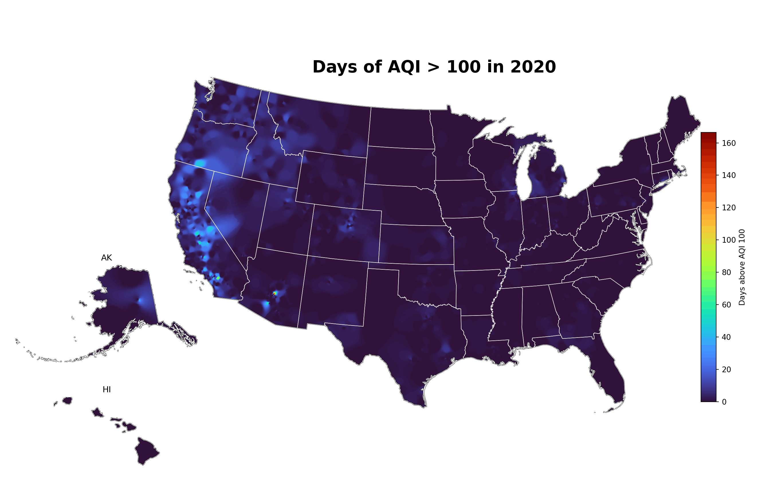
Geospatial Data Scientist | 🔥 Wildfire Modeling | Vegetation Ecology | Agriculture Technology |

Python R ArcGIS Cartography Spatial analytics

01 Toolbox

Combining environmental science training with geospatial engineering. Python, R, and ArcGIS are my core stack.

Languages

  • Python
  • R
  • SQL

Geospatial

  • ArcGIS · QGIS
  • GeoPandas · sf · terra
  • Rasterio · Raster processing

Data & Viz

  • Spatial statistics
  • Cartography & mapping
  • ggplot2 · Matplotlib · Plotly

02 Work

How I have used spatial datasets, visualization, and modeling.

Wildfire · Geospatial index

Wildfire Resilience Index

An index composed of high resolution (90m) spatiotemporal maps assessing wildfire resilience across western U.S. and Canada. We compiled over 100 unique geospatial datasets to assess socio-ecological wildfire resiliency. Data layers spanned domains such as infrastructure, health, vegetation, species, carbon, air, water and more.

PythonRQGISGeoPandasSpatial aggregation
🌾 Agriculture · Field experiment

Floral hemp nitrogen responses

Field-based analysis of floral hemp responses to nitrogen fertilization in the high desert, combining yield analytics, spatial context, and fertilization tracking.

Experimental designMixed dataSpatial analysisVisualization
Read the publication →
🏛️ Climate · Cultural heritage

Cultural heritage & wildfire exposure

Nationwide assessment of how cultural heritage sites in the United States intersect with wildfire risk, combining heritage inventories with hazard and exposure modeling.

Spatial joinsRisk & exposureArcGISCartography

In review at Scientific Reports.

03 Projects & Visualizations

This is a spin-off project from my work on WRI. Poor air quality has negative health outcomes and is an important dimension of public health and policy, especially in relation to wildfires. The Environmental Protection Agency has developed AQI thresholds above which there are increased health risks. AQI greater than 100 aims to represent base-level unhealthy air exposure for sensitive groups, while AQI greater than 300 aims to capture acute hazardous smoke events.

Animated map showing Days of AQI greater than 100 across the United States from 2020 to 2025.
AQI annual visual (2020–2025): IDW-based raster interpolation with a fixed turbo scale, shown as an animated loop.
View code on GitHub →
🐍

Python workflows

GeoPandas pipelines, spatial aggregation scripts, and map automation.

📊

R spatial analysis

sf, terra, and tidyverse-based reproducible analyses.

🗺️

ArcGIS & cartography

Map design, symbology, and publication-ready exports.

05 Publications

In review

MM Farnisa, BS Halpern, CR Fong. Nationwide exposure of United States cultural heritage to wildfire. Scientific Reports (in review).

In review

CR Fong, J Dudney, WD Hansen, MH Mockrin, MA Moritz, CJ Nolan, MP North, CM Tortorelli, RA King, CW Broderick, JM DeCesaro, EE Egg, MM Farnisa, BS Halpern. An index to assess wildfire resilience across the North American West. OneEarth (in review).

Published

Farnisa MM, Miller GC, Solomon JKQ, Barrios-Masias FH (2023). Floral hemp (Cannabis sativa L.) responses to nitrogen fertilization under field conditions in the high desert. PLOS ONE, 18(5): e0284537. DOI link.

06 Education

M.Sc. Natural Resources, Ecology & Environmental Science

University of Nevada, Reno

Minor in Data Analysis, Statistics, GIS

B.Sc. Energy, Climate, Sustainability & Environmental Science

Amsterdam University College, The Netherlands

Minor in Agroecology, GIS

Exchange Semester: Ecotoxicology & Marine Ecology

University of Queensland, Australia

Funding & Scholarships

Joan M. Comanor Scholarship (2021) - $1,500

Robert E. Dickenson Scholarship (2021) - $6,495

Nevada Agricultural Foundation Grant (2022) - $2,000

University of Nevada Research Grant (2021-2022) - $8,000

Undergraduate Academic Achievement Scholarship (2014-2017) - Full ride, Amsterdam University College

Selected for a competitive undergraduate exchange semester at the University of Queensland (Fall 2016).

07 Research & Fieldwork

Field-based research and lab work across environmental science.

Dayton Valley Aquaponics

Nevada, USA · 2018

Brix concentrations of greenhouse tomato varieties on varying nutrient cycles.

Heron Island Research Station

Queensland, Australia · 2016

Defense properties of coral mucus in the Great Barrier Reef against marine and human bacteria.

Moreton Bay Research Station

Stradbroke Island, Queensland, Australia · 2016

Determining PSII herbicide concentrations of five waterbodies in Queensland, Australia using combined chemical and bioassay analysis approach.